[EN] Hands that create mountains
[EN] Hands that create mountains
Matéria originalmente publicada em português na edição nº 1419 do Jornal Notícia. Traduzida para o inglês pelo Centro de Escrita.


publicado por
Agência UEL
Students on UEL’s Engineering, Architecture, Agronomy, Zootechnics, and Geography courses have access to a playful, easy-to-use teaching resource with almost limitless potential for the study of Topography. Even better, a practical and apparently simple resource: a sandbox.
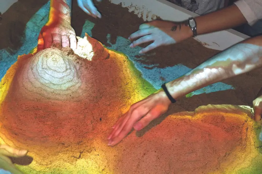
In fact, it is an augmented reality (AR) sandbox. It is a tool consisting of a wooden box (in this case, 80 x 120 cm), filled with 200 kg of ordinary sand, under a Kinect sensor (from an Xbox, yes, the one for video games) and a projector (a datashow), connected to a good computer, in a structure that allows the determination of the devices’ distance from the sand.
This set is the final product of the teaching project “Implementation and application of an AR sandbox in the teaching of topography and related areas”, coordinated by professor Paulo Adeildo Lopes, from the Department of Geology and Geomatics (CCE).
The sandbox was conceived by the Massachusetts Institute of Technology (MIT) in 2002 and gained notoriety when it was adopted at Harvard University in 2013 for teaching Geology and Geography. With it, it is possible to simulate all kinds of terrain and numerous geographical features literally with your hands. It is also possible to simulate vegetation, buildings, the effects of the weather, and even animals, such as fish in the water.
Process
There was a long process to achieve the current sandbox, explains professor Paulo Lopes. Before, to visualize a three-dimensional scenario, students built models out of cardboard sheets (thicker, often used for packaging) or even wood. To simulate changes in the terrain (due to rain and landslides), for example, they needed to make models with detachable parts. It was more challenging and in a static model.
Later, the professor started developing models with the students using smartphone applications, which represented an advancement in saving materials, work time, and manipulation of the scenarios. However, there were still many obvious limitations.
Then, the idea for the box came. The first one was made “by hand”, with the help of students, colleagues, and other collaborators. Getting the right equipment was also not easy.
After confirming that the resource worked, didactically speaking, Paulo Lopes joined other professors to achieve the current devices. He mentions that a complete set has to be imported and costs around 20,000 reais. The one at UEL, built here, cost approximately a third of that, but the professor notes that expenses such as carpentry, for example, were shared between five professors, all participants in the project.
Now, around 300 students “play” with the sand every week in the Topography and Geodesy Laboratory at CCE. Once the computer is programmed, which is very well embedded into the furniture, all you have to do is activate the Xbox and the projector, adjust the distance (height), and literally put your hands in the sand to create whatever scenario you desire — mountains, beaches, lakes, canyons, volcanos, hills, valleys, rivers, forests, contour lines, among many others.
Altitudes are distinguished by color — and there’s even “snow” if the mountain is high enough. Horizontal lines are displayed on the shapes to mark the predefined altitudes. The potential for modeling landscapes is only limited by the imagination.
For professor Lopes, real-time modeling is not only fun but also provides an immediate response to manipulation and allows scenarios and data to be visualized and projected more efficiently. This is because, besides being three-dimensional, it is tactile — an additional pedagogical advantage.
Evaluation
As this is a teaching project, students also evaluated the tool using an instrument devised by the professor. He mentions that the classes have approved the resource and notice the difference compared to previous methods, but still value the other stages. “Students like the theoretical part and still create models, understanding that these stages are important before reaching augmented reality,” says Paulo Lopes.
The project began in 2019 and had to be interrupted during the suspension of academic activities due to the COVID-19 pandemic, but it should come to an end in September 2023. The coordinator is producing the final report and preparing an article for publication. He considers the project successful: the material was created, it is being applied, it has been positively evaluated and it is available not only for undergraduates but also for future research.
Tradução: Loriane Santana, Bruna Lie Miura e Sabryna Maciel. Revisão: Lívia Seneda. Equipe do Centro de Escrita (CE).
Matéria originalmente publicada em português na edição nº 1419 do Jornal Notícia: Mãos que criam montanhas.